
GIS Data and System Integrations
Streamline your geospatial data and systems
Streamline your geospatial systems and data with our GIS integration services.
We can help you to manage significant spatial data sets – from asset management to location information – more efficiently. Our system integration service is there to transfer your valuable GIS data and make it usable among end users.
I-Finity has worked in the geospatial industry for many years now and has successfully supported its customers with large-scale data capture, hardware integrations, data processing and automated specific workflows for improved operational efficiencies.

Why use I-Finity for your GIS Integrations?
We offer a comprehensive range of services to support effective GIS data integrations, including:
- Cloud-based architecture: Our cloud-based approach for delivering GIS Software as a Service applications enables our customers to connect GIS data and streamline their operations.
- Integrations: Our delivery of integrations includes integrating with websites, apps, 3rd party APIs, hardware equipment and 3rd party software solutions.
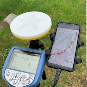
- Technical problem-solving: With over 50 years of technical problem-solving experience, our domain knowledge within geospatial is extensive which allows us to utilise previous experience to effectively support GIS integration projects no matter how complex they are. Proven experience in integrating locator sensors and GPS/GNSS devices. These devices include Trimble, Emlid, Umag, U-blox, Vivax, and many more.
- Accreditations: Recognised as a Microsoft Silver Partner for our work with Azure Cloud, aligning us well to deliver on GIS projects that require high reliability, availability and handling of large data sets.
Case Studies
Read our successful case studies focused on GIS integrations

As TerraFlow Geomatics’ software development partner we built TerraFlow Mobile. This platform allows seamless data collection and integration across surveying, construction, and utilities industries, bridging the gap between field operations and office-based analysis.

Designed to support ArcGIS Online, ArcGIS Portal, KML, CSV, and more, the TerraFlow Data Engine is a powerful Azure-based dashboard that automates data collection, ensures secure data transmission, and enables configurable workflows and sensor integrations, including cable and radiation detection.
Why GIS Integration is important
- Locational placements: GIS data integrated with end-user software allows you to survey an area to determine the safe placement of everything from temporary structures to electrical cables or sewerage.
- Route discovery: GIS data is integrated into GPS, allowing users to find the fastest route to a desired location.
- Tracking: GIS data can provide detailed statistical summaries on environmental factors of a location like roadworks and buildings. For example, the land and forestry industry use it to track tree-planting and landscape quality.
- Future planning: GIS data can be used to determine long-term plans. For example, where to place a Wind Farm to generate efficient volumes of electricity. This allows you to plan strategies precisely and accurately for eco-friendly benefits.
- Emergency response: GIS data can be used for hazard mapping, incident tracking, and resource allocation, allowing you to respond to emergencies quickly and efficiently.
Our spatial data sources
We can combine spatial data from many sources such as:
- Databases
- Software Applications and APIs
- Sensors and Locators
- GPS and GNSS devices
- Mapping Tools
- Many others
Benefits of GIS integration
- Informed decision-making: Correctly mapped GIS data allows better decision making by connecting and combining data sources into a map to identify patterns, trends and insights.
- Improved workflow efficiency: Geospatial data optimises workflow and resources, particularly within utilities and natural resource sectors.
- Effective asset management: GIS data can track, monitor and maintain physical assets to support utility companies.
- Collaboration and communication: GIS provides opportunities for dialogues between teams and departments by centralising data and compiling it into a user-friendly platform accessible to all relevant stakeholders.
Working with Trusted Technology Partners


Our GIS Integration Services
Our integration services for those in geospatial includes the ability to connect:

Sensors & Locators
Integrate with various types of sensors such as environmental monitors, weather, cable, radiation detection and metal detection. Update maps based on the data collected from sensors and locator devices.

GPS / GNSS
Consolidate data devices with geographic locations, and extract data to be integrated into maps.

API / Application / Web Service
Retrieve data from third-party platforms either by directly accessing their API or by using an available web service that provides real-time data access.

Data / databases
Establish connections with traditional databases, such as SQL and Azure, as well as spatial databases for managing location-based data.
This type of integration offers a powerful way to enhance our understanding of location, spatial relationships, and the complex interplay between geography and data. By merging data from multiple sources and visualising it through maps, it enables deeper analysis for more informed decision-making. With a holistic view of spatial relationships and diverse data inputs, you can make more strategic, data-driven choices.
BIM and GIS integration is the process of combining geographic information with infrastructure design data. This fusion provides a clearer understanding of how assets interact within their real-world environment, improving spatial awareness and decision-making.


